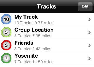
Track Group List
Tracks are always within a group. If you add a location and a group does not exist, one will be created automatically.
To view the tracks within a group, select the group from the list.
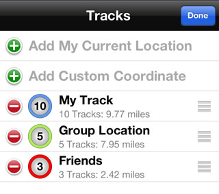
Editing Group List
The Group List can be edited by pressing the Edit button.
Deleting a Group
A Group can be deleted by swiping the item in the list and pressing the Delete button, or by entering edit mode and pressing the remove button and then the delete button.
Rearranging Groups
Groups can be rearranged in the list by grabbing the group by the tab on the right and moving it to a new location.
Adding Current Location
The user's current location can be added while in Edit mode by pressing the Add My Current Location option. If a group does not exist for the current location, one will be created.
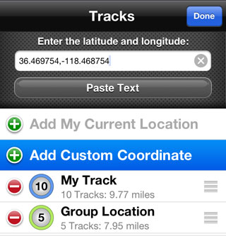
Adding Custom Coordinate
Pressing the Add Custom Coordinate option will display a textbox to enter a latitude and longitude. If a custom coordinate group does not exist one will be created.
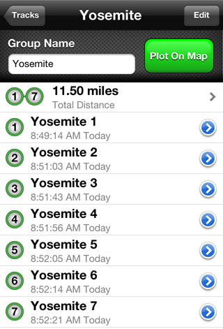
Group Tracks / Waypoints
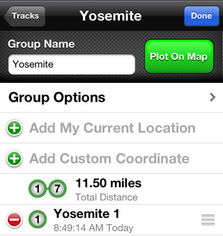
A Track Group consists of a name for the group and a list of tracks within the group.
Group Name
To change the name for a group, enter a new name in the Group Name text field.
Plotting a Group on Map
To all the tracks within a group on the map press the Plot On Map button.
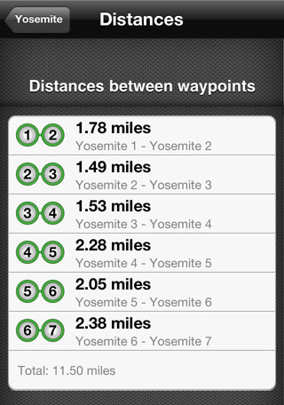
Distances
The top item in the list of tracks is the distance for the entire group. Select this item to see the distance between each track.
Editing Track List
Locations can be added to the group by pressing the Add My Current Location option or the Add Custom Coordinate option. These work in the same fashion as they do in the Group List. See above for more detailed information.
Removing Tracks
Tracks can be removed from the list by swiping the item and pressing the delete button, or entering edit mode, pressing the remove button and then the delete button.
Group Options
The Group Options item displays additional features for the selected group.
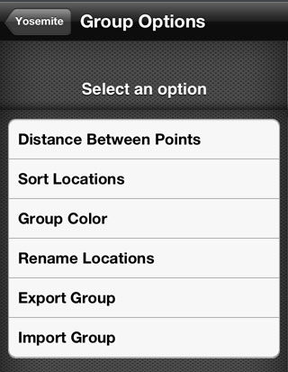
Distance Between Points
This option displays the list of tracks for the group and allows the user to select two items at a time to measure distances between the points.
Sort Locations
This option allows the tracks in the group to be sorted according to time or title, accending or decending.
Group Color
This option displays a color picker and allows the user to assign a color to the group. This color will be used when drawing the group on the map and icons for tracking.
Rename Locations
This feature automatically renames all the tracks in the group according to group name, adding a number to each item.
Export Group
Exports a .CSV (Comma Separated Value) file for the group. The file can be shared in a variety of ways including Google Drive, iCloud Drive, Dropbox, AirDrop, Mail, Messages, Notes, Previewed and Printed, or save for iTunes.
Import Group
Allows files to be imported from iTunes, iCloud Drive, Google Drive and Dropbox.