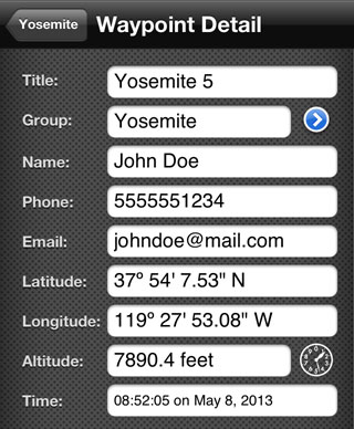
Track / Waypoint Detail
Each track has information associated with it.
Title - This is what is displayed on the map and in lists.
Group - This is the group the track is in. Pressing the disclosure button will display a list of existing groups.
Name - The name of the person that created the waypoint.
Phone - The phone number of the device that created the waypoint.
Email - The email of the device that created the waypoint.
Latitude - The latitude of the track.
Longitude - The longitude of the track.
Altitude - The altitude of the track. If the altitude was recorded using the GPS feature, the altitude will have a value. If created otherwise, the altitude can be determined by pressing the Altitude button.
Note: The Altitude look-up feature is provided by geonames.org.
Time - The time the track was created
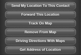
Waypoint Options
From a waypoint detail, you can choose to do the following with the waypoint:
Send My Location To This Contact
This will create a message to the contact associated with this track containing the user's current location.
Forward This Location
Creates a message containing the location of the track and allows it to be forwarded to another person.
Track On Map
This will display the track on the map and track it.
Remove From Map
This will remove this track from the map and stop tracking it.
Driving Directions With Maps
This will open the Maps app and show driving directions to this track.
Get Address of Location
This will reverse geocode the location for the waypoint and display the address.